")
")

Kwang Binh Holiday Weather today
Date/time of update: April 26, 2026, 1:37 am, Timezone: GMT+7
Overcast Clouds
Temperature: 26.81°C
Temperature feels like: 29°C
Minimum Temperature: 26.81°C
Maximum Temperature: 26.81°C
Atmospheric pressure: 1013hPa
Humidity:76%
Visibility: 10000m
Wind speed: 1.86m/sec
Wind Direction: 101 degrees
Cloudiness: 91%
Sunrise: 2026-04-25 10:30:31
Sunset: 2026-04-26 11:12:07
Quang Binh is located in the Central Region of Vietnam. The province is bordered to the north by Ha Tinh, to the east by the East Vietnam Sea, to the south by Quang Tri and to the west by Laos. The coastline of Quang Binh is 116km and the borderline with Laos is 202km.
Quang Binh Geography
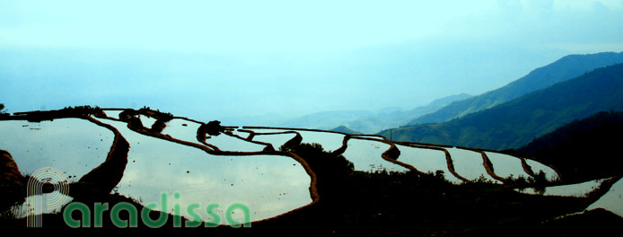
The terrain of Quang Binh is narrow, higher to the west and lower to the east. 85% of Quang Binh’s land is mountainous. The high mountains are to the west, low hills in the middle and flat plains and sandy areas along the eastern coast.
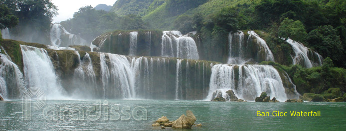
 There are 5 main river systems in Quang Binh flowing from the west to the east discharging the waters into the East Vietnam Sea via 5 estuaries: Ron, Gianh, Ly Hoa, Dinh, Nhat Le. Most of these rivers originate from the mountains to the west of Quang Binh.
Quang Binh Climate, Best Time to Visit Quang Binh
The climate of Quang Binh is tropical monsoon with two seasons: the dry season from April through August and rainy season from September through March. The hottest months are June, July and August in which the temperatures may be above 40oC; the coldest months are December and January. The average annual rainfall is 1,500-2,000mm. Most of the rainfalls are in September, October and November. There are often typhoons during the rainy season.
People and Population in Quang Binh
The ethnic groups in Quang Binh include: Kinh, Bru - Van Kieu and Chut. The Bru – Van Kieu and Chut account for 2.3% of the provincial population. The Bru – Van Kieu includes Van Kieu, Khua, Ma, Coong, Tri; the Chut includes Sach, May, Ruc, A Rem, Ma Lieng.
Quang Binh Travel Guide, Tourist Attractions, What to see in Quang Binh
Quang Binh is a narrow piece of land in the Central Region of Vietnam bounded by the forested Truong Son Mountain to the west and white sand dunes and blue sea to the east. There are several valleys created by forested limestone mountains and There are several rivers running through forests and valleys that make the natural landscape of Quang Binh among the first idyllic in Vietnam.
Just close to the DMZ and home to some important legs of the legendary Ho Chi Minh Trails, Quang Binh was heavily bombed and destroyed in the war. While the vegetation has recovered mostly, and towns and villages have been rebuilt, there are several historical spots in Quang Binh that you can visit and learn about the events in the war.
1/ Phong Nha - Ke Bang National Park
Quang Binh had been little known to the foreign travelers to Vietnam until Phong Nha Ke Bang was inscribed to the UNESCO World Heritage Sites. The National Park of Phong Nha – Ke Bang is home to the longest underground river in the world. The stunning scenery of the caves at Phong Nha – Ke Bang have attracted thousands of cavers in the world to Quang Binh turning it into among the most popular attractions in Vietnam. For more on Phong Nha Ke Bang Nation Park, please refer to Paradissa’s Vietnam national parks section for more information.
2/ Nhat Le Beach and Bao Ninh Beach
Nhat Le Beach and Bao Ninh Beach offer the travellers with white sand, blue sea water and fresh local seafood. The good thing is that it's off the well trodden tourist paths and there are luxury 4-star hotels and beach resorts with private beach for accommodation. Nearby there are amazing sand dunes and fishing villages.
3/ Ho Chi Minh Trails
Ho Chi Minh Trails were a network of trails used to supply troops and ammunition from the North to the South of Vietnam in the war. The total length of the trails was over 20,000 km crossing many high mountain peaks of over 2,500 m and deep abysses. The most destroyed legs of the trails were around Quang Binh and Quang Tri Provinces, especially Quang Tri where there was the McNamara Line. Still the flows of enforcement from north to south Vietnam were not stopped.
 Ho Chi Minh Trails have been made into highways between northern and southern Vietnam. Still, some parts of the trails are left intact or encroached by jungles. You can tour a sample of these trails in Phong Nha - Ke Bang National Park.
Things to do, Travel and Tours in Quang Binh
1/ Caving adventures, trekking tours in Quang Binh
There are several sightseeing tours, trekking tours and caving tours visiting caves, valleys and forests at Phong Nha – Ke Bang National Park. The tours take from 1 day to several days. There are several tour operators in Dong Hoi and Phong Nha – Ke Bang who could arrange these tours.
2/ Beach Vacations in Quang Binh
If caves and adventures are not of your interest, then you may like a relaxing vacation on the beaches at Dong Hoi where the service is suitable to a wide range of budgets. You can choose the simple hotels facing the beach or go into beach resorts with luxury travel service and with a private beach. If you are not sure of what to do at Quang Binh, then contact Paradissa for ideas on holiday packages in this less visited land.
3/ Paradissa’s recommended tour itinerary
Paradissa’s recommended itinerary is to board an overnight train from Hanoi and arrive at Dong Hoi the next morning. Our tour guide and car will be ready to pick you up and transfer you to Phong Nha National Park for sightseeing and tours. In late afternoon, we'll drive back to Dong Hoi and enjoy a relaxing time at a luxury beach resort. The next morning, we'll continue with a full day tour of the DMZ and arrive at Hue Imperial City for the night.
Accommodations in Quang Binh
There are several choices in terms of accommodation for the visitors in Quang Binh. If you stay at Dong Hoi and there are simple hotels in town, simple hotels opposite the beach or luxurious beach resorts. For those who love nature and idyllic countryside, then you can stay at neat homestay or guest houses at Phong Nha – Ke Bang. Some homestays are on a riverside with amazing landscape around.
Getting there and away, getting around
1/ By road
Dong Hoi, the provincial capital of Quang Binh, is located 100 km north of DMZ, about 170km north of Hue and 488km south of Ha Noi. Dong Hoi City is 50km from Phong Nha – Ke Bang National Park via the eastern leg of Ho Chi Minh Trail.
Cha Lo International Border Checkpoint is between Cha Lo (Minh Hoa, Quang Binh, Vietnam) and Naphao (Bualapha, Khammouane, Laos). Cha Lo is 160km from Dong Hoi.
2/ By air
There are several daily flights to/from Dong Hoi Airport from/to Hanoi and Ho Chi Minh City. There are also direct flights between Dong Hoi and Chiang Mai (Thailand.)
3/ By railways
From Ha Noi you can board an overnight Reunification Express trains to Dong Hoi.


Dong Hoi Average Monthly Rainfall and Temperatures


, Dien Bien Phu Battle")


