")
")

Ha Long Holiday Weather today
Date/time of update: June 9, 2026, 12:00 am, Timezone: GMT+7
Overcast Clouds
Temperature: 23.43°C
Temperature feels like: 24.07°C
Minimum Temperature: 23.43°C
Maximum Temperature: 23.43°C
Atmospheric pressure: 1005hPa
Humidity:86%
Visibility: 10000m
Wind speed: 2.54m/sec
Wind Direction: 13 degrees
Cloudiness: 100%
Sunrise: 2026-06-08 10:09:49
Sunset: 2026-06-09 11:32:07
Halong Bay of Vietnam offers 3000 green limestone islands rising from the crystalline emerald water in the Gulf of Tonkin. Ha Long Bay also has tens of stunning limestone caves above and under water, and the diverse Eco-system which makes the bay listed as the World Heritage Site by the UNESCO (United Nations Educational, Scientific and Cultural Organization).
Geography of Halong Bay
To the north, Halong Bay Islands run close to the Chinese border; to the south the islands run along Hai Phong City. The total is about 1553 km2. The special zone claimed specially protected by the UNESCO is about 300 km2. The biggest island is Cat Ba 354 km2 with the inhabitants living on agriculture and fisheries.

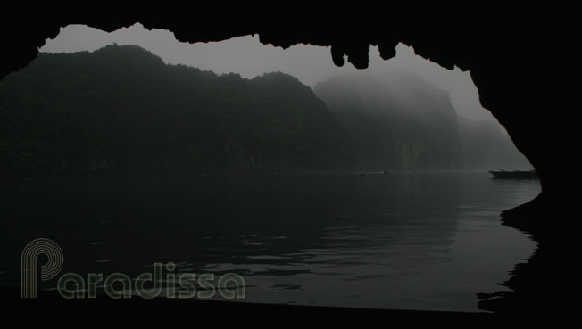
Junk cruise in the tranquility at Bo Nau Cave of Ha Long Bay
Halong Bay’s Climate
January: below 10-18oC, often dry, sometimes wet due to drizzles and occasionally foggy.
- February: below 10-18oC, often dry, sometimes wet due to drizzles and often foggy.
- March: 15-22oC, often dry and often foggy.
- April: 20-28oC, dry and occasionally foggy.
- May: 30-35oC, humid, there are occasionally torrential rains which last for a couple of hour each.
- June: 33-40oC, humid, there are occasionally torrential rains which last for a couple of hour each. There are occasionally typhoons during which junks/boats are not allowed to set out and cruise on the bay.

The real paradise of Halong Bay of Vietnam with the unreal beauty
- July: 30-40oC, humid, there are occasionally torrential rains which last for a couple of hour each. There are occasionally typhoons during which junks/boats are not allowed to set out and cruise on the bay.
- August: 25-33oC, not humid, there are occasionally torrential rains which last for a couple of hour each. There are occasionally typhoons during which junks/boats are not allowed to set out and cruise on the bay.
- September: 23-33oC, not humid, there are occasionally torrential rains which last for a couple of hour each. There are occasionally typhoons during which junks/boats are not allowed to set out and cruise on the bay.
- October: 20-28oC, not humid, there are occasionally torrential rains which last for a couple of hour each. There are sometimes typhoons during which junks/boats are not allowed to set out and cruise on the bay.
- November: 18-22oC, dry most of the time and wet due to drizzles sometimes. There could be, though rarely, typhoons on Halong Bay during this time.
- December: below 10-18oC, dry, normally clear sky and windy.

The Luon Lagoon on Halong Bay, Vietnam
Halong Bay's Legend
Halong Bay (Vinh Ha Long) in Vietnamese means "the Bay of Descending Dragons". According the Vietnamese legend, the area was inhabited early by the Vietnamese who lived mainly on agriculture. There were a herd of dragons which brought about rain to water the paddy fields. Life was very peaceful and happy...

One day came the aggressors from the sea. They killed the people and looted the their villages. Their cries reached heaven and the dragons were sent down by the King of Heaven to help them. The dragons descended in the bay and spat out pearls which turned into limestone islands stopping the invaders' advance, they wriggled their tails to destroy the invaders' boats. Soon the invaders were defeated and peace was brought back to the country. The dragons remained in the bay to protect it forever.

The unreal beauty of Halong Bay reveals after half an hour cruise from the shore
The bay has two main areas: to the north was where the child dragons landed, hence the name Bai Tu Long Bay (or the Bay of the child dragons bowing to the mother); to the south was where the mother dragon landed which got it the name Halong Bay. Besides, there's an area near Cat Ba Island called Lan Ha Bay (or " the Summer Orchid Bay") which got the name from the wild orchid flowers here in the summer.

Halong Bay from the top of Ti Tov Mountain
Halong Bay's Geology
Researches proved that Halong Bay was created by the undulation processes which took place on the earth surface from around 300 million years off and on to 175 million years ago. The wave-like motions involved cracking, sinking and lifting some areas and the islands were created. There are water lines at top of some caves in the bay which proves that it was underwater some time in the past. Sometimes, Halong Bay was a fresh-water region; there are still vestiges of ancient rivers which ran in the middle of the bay area; and at Me Cung Cave lots of fossilized shells of fresh water mollusk are still found.

Swan Islet Halong Bay Vietnam
Most mountain and islands of Halong Bay are of limestone with colors ranging from chalky white to black. Thre are stunning colorful caves on many islands. There are many secret lagoons and lakes of which some can be accessed at low tides only. At high tides the opening is under water.
At most points in Halong Bay, the water depth ranges from 4 meters to 8 meters. Near the open water (such as that at Cua Van) it may be 45 meters deep.

Sunset on Halong Bay
Halong Bay's Civilizations
The earliest civilization recorded in Halong Bay was around 3500 - 2000 BC and it was called Cai Be Civilization. This one seemed to have connections with other civilizations in Vietnam of the time such as Dong Son, Hoa Binh, Sa Huynh, Oc Eo to create the golden period in the prehistoric times of Vietnam.

The Dinh Huong Islet Halong Bay Vietnam is among the first islands of Halong Bay encountered on a cruise
Halong Bay Travel Guide, Halong Bay's Tourist Highlights
1/ Ha Long Fish Market
Ha Long fish market is in Hon Gai Town with different kinds of seafood caught in Halong Bay. There are also different kinds of electronic goods nearby. From Bai Chay Town you can hire a Xe Om or taxi to get to Halong Fish Market via Bai Chay suspension bridge.
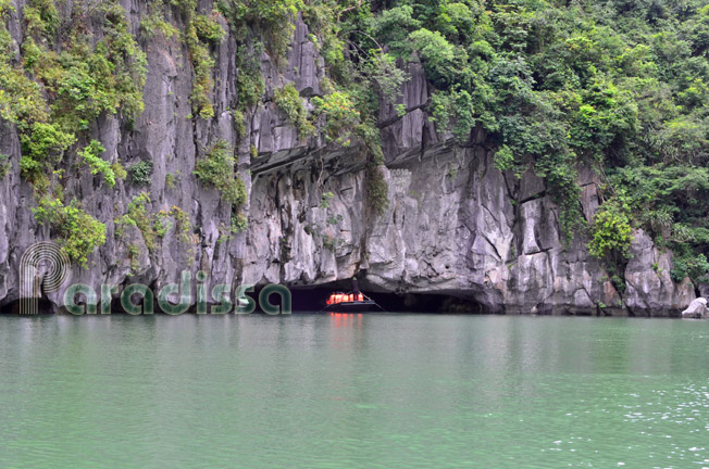
2/ Dau Go Cave and Thien Cung Cave
Dau Go Cave is on an island 7km from the shore. The cave was where the Vietnamese troops hid stakes which were later used for make traps in the war against the Mongol troops in the 13th century.
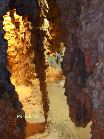
Near Dau Go cave (on the same island) is Thien Cung Cave (Cave of Heavenly Palace) with unreal rock formations which make it have a heavenly look. Visit both Dau Go and Thien Cung would take 1.5 hour.
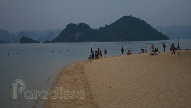
3/ Ti Tov Beach
Ti Tov Beach was where Ho Chi Minh and Ti Tov - a Russian astronaut had a swim while Vietnam was at war. The beach was named after the Russian one. At top of Ti Tov Island, there an observation tower which offers stunning panoramic view of Halong Bay.
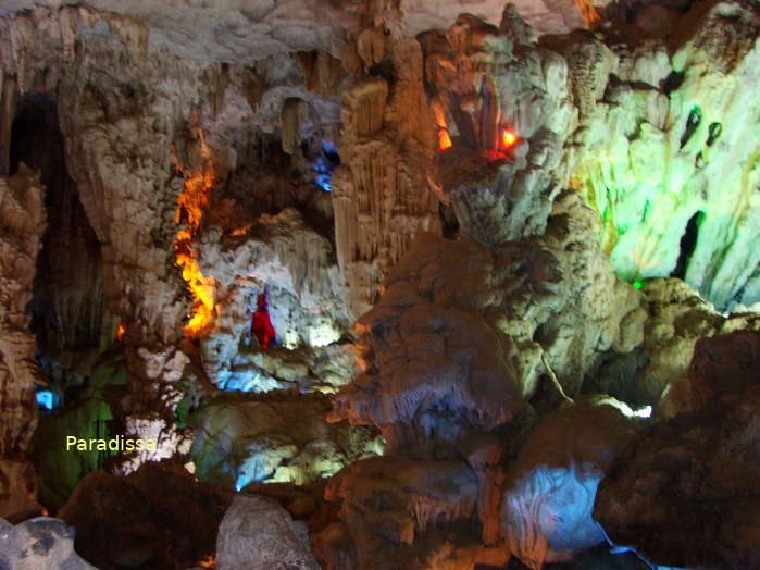
4/ Sung Sot Cave
Sung Sot Cave (the Cave of Amazement) and amazing it is. The cave is large of over 200 m long and it was under water during the glacier time. The ceiling still has the punching marks of water that time. It's quite a walk to this cave, though the reward is definitely worth it!
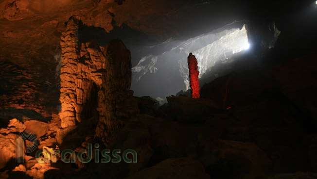

5/ Luon Cave
Luon Lagoon is one among several lagoons on Halong Bay which has only 1 opening as the entrance. The lagoons are surrounding by towering limestone mountains. Some lagoons are accessible at low tide only as the opening is underwater at high tide.
6/ Me Cung Cave
Me Cung Cave (Cave of Labyrinth) is in a mountain on a sea passage to Cua Van and the open sea. The cave offers magnificent views of the surrounding and the secret lagoon created by the same mountain.
7/ Oyster Farms
Oyster farms there are quite a few oyster farms out on Halong Bay which can be visited on a rowing boat or by kayaking.
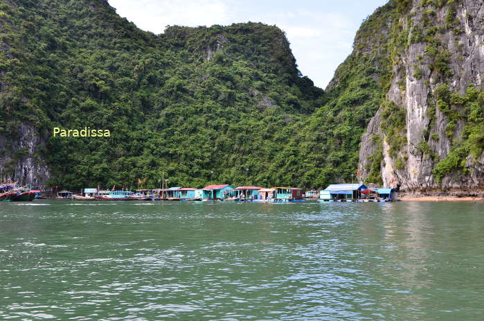
8/ Floating Villages and Schools
Floating villages are home to fishermen on Halong Bay. They live there for life and travel to the shore every few days for food and daily necessities. There are also floating schools on the bay. These villages are easily visited by rowing boat and kayak.
Things to do, Luxury Travel and Tours, Family Trips, Luxury Cruises in Halong Bay
1/ Luxury Boat Cruises on Halong Bay
Have Long Bay can be visited by boat for 3-8 hours upon request. Or the traveler can book a luxurious junk cruise on Halong Bay with overnight on board in the wild of the bay. There are options to book a private cabin on a shared junk or book a chartered junk cruise. Nowadays you can get the style of luxury travel services on Halong Bay which exactly suits your taste!

Halong Bay Wild Cruise
2/ Kayaking
Kayaking is an option for the travellers who would like to visit the unseen lagoons, mountains and islands that are not accessible by big boat.
3/ Luxury Tours to Halong Bay
From Ha Noi you can take a 1-day, 2-day or 3-day tours to Halong Bay. The travelers who like to take kayaking tours or combine the tour with a trip on Cat Ba Island can extend the time.

Sunset cruise on Halong Bay Vietnam
4/ Family Holidays, Vacations for couples on Halong Bay
Families planning holidays on Halong Bay have several options. You can choose a luxury private cruise or a shared cruise for your family. For couples on a romantic vacation or honeymoon trip may like to hire a small boat of 1 or two cabins and venture into the less visited areas of Halong Bay.
Families with kids may like to have an extra day to cruise further from the shore or you may like to have time for a walking tour or leisure bike trip to visit fishing villages on an island.
5/ Paradissa, a Local Tour Company & Operator, with Handcrafted Cruises on Halong Bay
Paradissa, an experienced tour agency and cruise agency for luxury cruises on Halong Bay could help you with memorable cruises on this natural wonder of Vietnam.
On Paradissa’s 2-day luxury cruises on Halong Bay, you’ll visit the the most beautiful area of Halong Bay with overnight on board near Sung Sot Cave. The highlights: lovely cruise amid spectacular scenery, sensational fresh seafood, amazing caving experience, spectacular panoramas of Halong Bay from the top of Ti Tov Mountain.
On Paradissa’s 3-day luxury cruises on Halong Bay, you’ll get all the highlights as on a 2-day cruise. Besides, you’ll have another full day cruising father afield depending on the weather it could be a cruise plus kayaking amid unreal kastic formations near Cat Ba with myriads hidden caves and lagoons or it could be lovely kayaking in the secret lagoon of Ho Ba Ham.

A spacious cabin on a luxury cruise boat on Halong Bay
Where to stay, Accommodation in Halong
There are many hotels in Ha Long City ranging from simple guest houses to luxurious 4 star hotel. Rooms and services range from simple and basic, adventure to luxury travel. There are hotels high in the hills which offer lovely panorama of Halong Bay. There is a resort on Tuan Chau Island for those who love on the beach for a few days.

A luxury cruise boat on Halong Bay
Getting there and away
1/ By air
Halong Bay is 1 hour flight by helicopter from Gia Lam Airport in Ha Noi. Alternatively, there are different daily flights to Van Don Airport, 50km north of Halong City.
2/ By road
Halong Bay is 160km or 3.5 hours drive from Ha Noi. The road is fairly good, though traffic may be very busy. There are many local bus companies from commuting between Ha Noi - Ha Long City. The buses don't have seat numbers and the driver may stop many times to pick up more passengers on the way until it's totally stuffed. Also, all commuter bus drivers have to hurry to pick up as many people as possible on the way; they drive very recklessly.
Halong Bay can also be visited by road from Hai Phong. It's only 70km between the 2 cities and the drive takes 1 hour.
3/ By boat
From Hai Phong you can take a speed boat for 1 hour to Cat Ba Island where you take a 5 hour boat cruise weaving through Halong Bay islands.
Getting around Halong
1/ On foot
Bai Chay Town ( the tourist area of Ha Long City) can easily be explore on foot. There are nice walk on the waterfront and it's safe to stroll here at night.
2/ By Taxi
Ha Long taxi (with meter) can be called for longer distances in the city, say from Bai Chay to Hon Gai (the area for the local residents).
3/ By Xe Om (motorbike taxi)
There are many Xe Oms with drivers on every corner of Ha Long City who are ready to take you anywhere in town.
4/ By Boat
To visit Halong Bay then having a boat cruise is a must. There are different boat classes ranging from simply converted fishing boat to air-conditioned luxurious junks.
Halong Bay (Hon Gai ) Average Monthly Rainfall and Temperatures


, Dien Bien Phu Battle")


