")
")
")
Dien Bien Phu Holiday Weather today
Date/time of update: April 27, 2024, 12:41 am, Timezone: GMT+7
Clear Sky
Temperature: 28.78°C
Temperature feels like: 28.39°C
Minimum Temperature: 28.78°C
Maximum Temperature: 28.78°C
Atmospheric pressure: 1008hPa
Humidity:40%
Visibility: 10000m
Wind speed: 1.1m/sec
Wind Direction: 250 degrees
Cloudiness: 0%
Sunrise: 2024-04-26 10:39:31
Sunset: 2024-04-27 11:31:20
C1 Hill (Eliane 1) belonged to the Eliane Group protecting the French Hedgehog at Dien Bien Phu from the east. Eliane 1 was located 1.2km slightly to the northeast of the French Commander Post.
There was also C2 Hill or Eliane 4 (to the southwest of C1) of the Eliane Group. C1 and C2 formed an axis stretching from northeast to southwest. C2 was to 1km the east of the French Commander Post. C1 (50m high) was slightly higher than C2 (42m high).
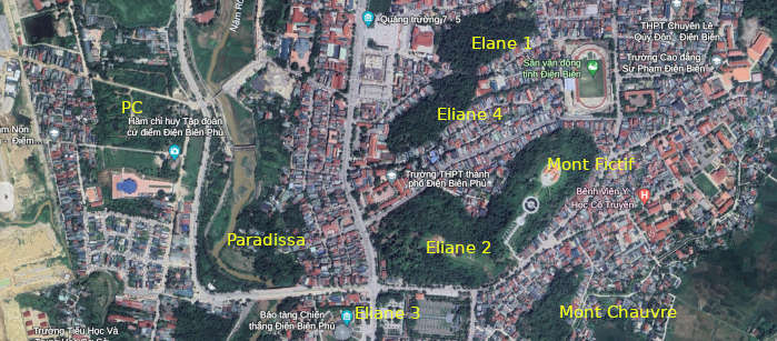
The French positions on C1 were 100m from the French positions on C2. During the battle of Dien Bien Phu, there was a hill in the middle of these two hills. Nowadays, the two hills are separated by a hilly road of 15-20m wide. The two hills were 200m east of Route 41 which ran north-south. And the French Commander Post (PC) was 800m west of C2 across the Muong Thanh Bridge (Bailey Bridge). Back to the time of the Battle of Dien Bien Phu, French tanks could move freely along Route 41 and between the PC and C1, C2.
Dien Bien Average Monthly Rainfall and Temperatures


, Dien Bien Phu Battle")


